Even as Hurricane Irma hits the Caribbean as the strongest Atlantic storm ever recorded, the National Hurricane Center reports that it is monitoring the progress of two more tropical storms.

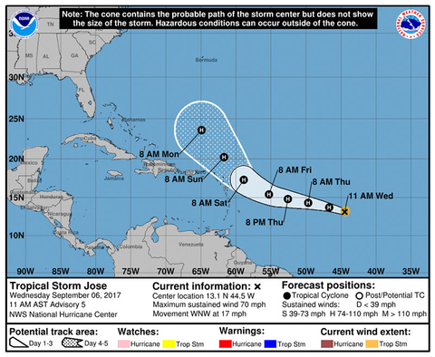
Tropical Storm Jose is currently located in the Atlantic. With maximum sustained winds near 65 mph, the storm is expected to strengthen into a hurricane by later today. The storm is currently heading west-northwest. While there are no coastal watches or warnings in effect, interests in the Leeward Islands are advised to monitor the progress of the storm.

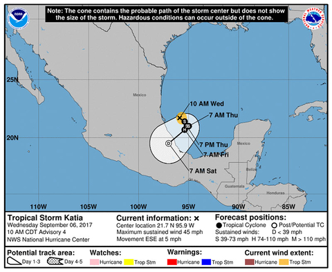
Tropical Storm Katia, meanwhile, is centered near Mexico with maximum sustained winds near 45 mph. The storm could strengthen to become a hurricane before approaching the state of Veracruz within the next couple of days, and a hurricane watch could be required for portions of Veracruz later today.
Katia is expected to bring five to 10 inches of rain to northern Veracruz, and two to five inches over southern Tamaulipas, northeast Puebla and southern Veracruz through Saturday morning. The rain may cause life-threatening flash floods and mudslides.
Airlines have not yet issued any updates on flight cancellation or change waivers as a result of the two storms at this time.
According to the latest forecast from Colorado State University, which was released in early August, we’re in the midst of an above-average hurricane season. The forecast predicted 11 named storms from August through the end of the season due to unusually warm temperatures in the tropical and subtropical Atlantic.
Related Stories
Caribbean Tourism Organization Issues Statement on Hurricane Irma
Harvey Update: Houston Airports Resume Limited Domestic Service
State Department Extends Europe Travel Alert Through November
BA Cancels Flights as Caribbean and Florida Prepare for Hurricane Irma